
VIP member
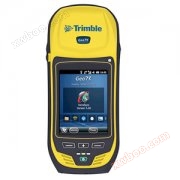
Trimble Tianbao GEO 7X
The latest mobile GIS data collection tool GEO 7 series developed by Trimble in the United States has caused a strong response in the GIS industry! It
Product details
The GEO 7 series new product is Trimble's latest mobile GIS data acquisition technology. Its biggest feature is the integration of GIS data acquisition and laser ranging, and more importantly, it is compatible with five mainstream GNSS satellite positioning systems, including GPS, GLONASS, Galileo, Beidou, and QZSS (QZSS is Japan's quasi zenith satellite system). No matter what challenges your field work encounters, the new generation of fully integrated high intelligence one-stop solution will become your first choice for equipping field work teams.
Tianbao GEO 7 Series New Products

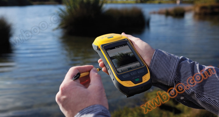
The GEO 7 series new products still inherit Trimble's high-quality design style, rigorous quality control, and accurate market positioning. The main features include Trimble Flightwave remote positioning technology, Trimble Floodlight satellite shadow elimination technology, improving your GNSS data productivity, and end-to-end data collection. The channel count of this series of products is 220, with centimeter level accuracy and a maximum accuracy of 1cm. Its operating system is Windows Mobile 6.5 Professional Edition, CPU is DM3730 1GHz+GPU, memory is 4GB user memory+256MB, flash memory can be expanded up to 32GB, it comes with a 5-megapixel autofocus and geotagging camera, and a 3.5GB mobile cellular modem. Its industrial protection level is IP 65, the screen is 4.2-inch VGA (640X480) LED semi reflective, the battery life is up to 10 hours, and the standby time is up to 50 days. It integrates azimuth sensors such as 3-axis gyroscope, magnetometer, accelerometer, etc., supports Bluetooth and wireless, and can be optionally equipped with a laser rangefinder module, with a range of up to 120m to 200m and an accuracy of up to 5cm. This completely eliminates the cost and trouble of equipping other laser rangefinders when conducting eccentricity measurements in the field. Simply point the device at the target and align it, and you can easily obtain all the high-precision GIS data you want. In addition, the new products in this series fully support languages. Truly achieving worry free operation with one machine in the field of GIS data acquisition!

Tianbao GEO 7 Series New Products
The GEO 7 series new products still inherit Trimble's high-quality design style, rigorous quality control, and accurate market positioning. The main features include Trimble Flightwave remote positioning technology, Trimble Floodlight satellite shadow elimination technology, improving your GNSS data productivity, and end-to-end data collection. The channel count of this series of products is 220, with centimeter level accuracy and a maximum accuracy of 1cm. Its operating system is Windows Mobile 6.5 Professional Edition, CPU is DM3730 1GHz+GPU, memory is 4GB user memory+256MB, flash memory can be expanded up to 32GB, it comes with a 5-megapixel autofocus and geotagging camera, and a 3.5GB mobile cellular modem. Its industrial protection level is IP 65, the screen is 4.2-inch VGA (640X480) LED semi reflective, the battery life is up to 10 hours, and the standby time is up to 50 days. It integrates azimuth sensors such as 3-axis gyroscope, magnetometer, accelerometer, etc., supports Bluetooth and wireless, and can be optionally equipped with a laser rangefinder module, with a range of up to 120m to 200m and an accuracy of up to 5cm. This completely eliminates the cost and trouble of equipping other laser rangefinders when conducting eccentricity measurements in the field. Simply point the device at the target and align it, and you can easily obtain all the high-precision GIS data you want. In addition, the new products in this series fully support languages. Truly achieving worry free operation with one machine in the field of GIS data acquisition!
As is well known, Trimble, an American company with a development history of about half a century, has always been at the forefront of the international mobile GIS field. In recent years, it has also steadily and gradually become stronger, focusing on building a mature and advanced comprehensive resource platform that integrates surveying and mapping with mobile geographic information, mobile computer service system applications, mobile 3D spatial information surveying, GIS system integration and software research and development, spatial geographic data engineering, etc. It accurately covers one-stop fields such as GIS data acquisition, analysis, processing, and application. For Trimble's newly launched fully integrated high intelligence product, let's welcome the stunning launch of Trimble GEO 7 series!
| Geo 7X GNSSReceiver | |||
| Technical Specifications | Detailed specifications | ||
| Physical performance indicators | size | 23.4cm×9.9cm×5.6cm |
|
| weight | Geo 7X Handheld Phone 963g | ||
| Geo 7X handheld device with rangefinder 1080 g | |||
| operating system |
Windows Mobile 6.5 Professional Edition |
||
| processor |
DM3730 1Ghz+GPU |
||
| memory |
4GB user memory+256MB RAM |
||
| battery |
Built in 11.1V, 2500mAH rechargeable lithium battery, capable of continuous operation for 10 hours Standby time up to 50 days, fully charged time<4 hours |
||
| environment | Operating Temperature |
-20℃~+60℃ |
|
| Storage temperature |
30℃~+70℃ |
||
| seal |
Completely waterproof and dustproof, IP65 standard; Anti sliding, impact and vibration |
||
| fall |
Resistant to 1.22m drop, MIL-STD-810F; Test Method 516.5, Program IV |
||
| expand | storage |
Sealed SD card expansion slot (SD card and SDHC up to 32GB) |
|
| videography |
5-megapixel autofocus with geotagging function, supporting TIFF, JPG and other formats |
||
| Input | display |
4.2-inch screen, VGA (480 × 640 pixels) Polarized screen that can display clearly from multiple angles under strong light, LED semi reflective type |
|
| interface |
Touch screen operation, 4 control keys, virtual alphanumeric keyboard |
||
| 1 power status LED indicator, microphone and speaker Audio system events, warnings, and notifications |
|||
| I/O |
USB2.0 |
||
| wireless | Built in 3.5G communication module | ||
| Bluetooth 2.0, Wireless LAN802.11b/g | |||
| GNSS | satellite |
220 channels, using Trimble Maxwell 6GNSS chip, |
|
| Supports GPS, GLONASS, Galileo, Beidou, and QZSS, L1/l2 | |||
| Integrate real-time differential mode |
SBAS (WAAS/EGNOS/MSAS/GAGAN) dual channel tracking |
||
| Update rate | 1Hz | ||
| Initialization time |
<45 seconds (under normal circumstances) |
||
| agreement | data output | TSIP, NMEA-0183 (optional) | |
| Real time correction | RTCM2,x/RTCM3, x/CMR,CMR+/CMRx | ||
| precision | Real time centimeter mode accuracy |
Horizontal 1cm ± 1ppm HRMS |
|
| 垂直1.5 cm±2ppm VRMS |
|||
| Post processing centimeter mode accuracy |
Horizontal 1cm ± 1ppm HRMS |
||
| 垂直1.5 cm±1ppm VRMS |
|||
| H-Star Technology |
10cm±1ppm HRMS |
||
| Code accuracy | Real time 75cm ± 1ppm HRMS | ||
| Post processing 50cm ± 1ppm HRMS | |||
| SBAS(WAAS/EGNOS/MSAS) |
<1m, Sub meter level accuracy |
||
| Static measurement |
5mm±1ppm |
||
| special performance | position sensor | 3-axis gyroscope, magnetometer, accelerometer Heading accuracy of 1.5 ° Tilt angle accuracy 0.5 ° Tilt accuracy 0.5 ° |
|
| distance sensor |
Optional laser rangefinder module with an accuracy of 0.05m Passive range up to 120m The reflection range can reach 200m |
||
| Floodlight satellite shadow elimination technology | support | ||
| SBAS+ | support | ||
Online inquiry
-
Contacts
-
Company
-
Telephone
-
Email
-
WeChat
-
Verification Code
-
Message Content
-